Haiti is an island state on the island of Hispaniola in the Great Antilles. It includes the western part of the Caribbean island. The eastern part of which is the Dominican Republic.
Also, the approximately eleven million inhabitants of Haiti are mostly of sub-Saharan African descent. The capital of the country is Port-au-Prince. It is bordered to the north by the Atlantic Ocean. In like fashion, to the east by the Dominican Republic. Also, to the south by the Caribbean Sea. Still, to the west by the Canal du Vent. Canal du vent separates the island from Cuba.
Geographical
The country covers 27,750 square kilometers. Its capital Port-au-Prince is at the bottom of the Gulf of Gonave.
Gulf of Gonave separates the two peninsulas of haiti. Thus, Gonave is the largest of the islands off its coast. Turtle Island, famous as a den of buccaneers in the 17th century is in the north of the country. Cow Island is in the southwest in the Caribbean Sea off Les Cayes.
The country has a very rugged terrain. It is mainly mountainous with massifs oriented east-west. Also,narrow valleys sepparate the country. The highest peak on the island is in the Selle massif which rises to 2,640 m.
Mountain ranges almost everywhere border the coastlines, which are very cut out. Rivers are difficult to navigate.But, the main one, the Artibonite is partly navigable. The country has two large lakes near the Dominican border.
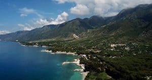
The climate is tropical. The rainy season extends from April to June and from October to November. The west coast and the island of Gonave enjoy a dry and warm climate. The average temperature is 27degree and very little thermal variation between summer and winter.
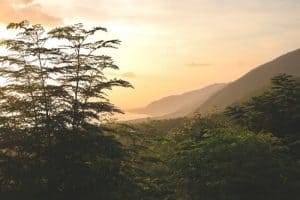
The mountains in the south and north of the country, as well as the narrow coastal plains have a colder and more humid climate.
Further, Haiti has ten departments. The government appoints head of the departments. Also, the capital Port-au-Prince is by far the largest city in the country with over 2,100,000 inhabitants.
The other agglomerations are much smaller.Cap-Hatien is in the north. Les Cayes is in the south and Les Gonaves in the west
.
Haiti borders
Haiti’s neighbors include the Turks and Caicos, the Dominican Republic, Jamaica, Cuba and the Bahamas. The territory has the shape of a “U” open to the west, formed by two long peninsulas. In between lies the Golfe de la Gonve. Moreover, at the eastern end of which lies the capital Port-Au-Prince.
The highest mountain with a height of 2674 m is Pic la Selle. It lies in the southeast of the country in the Sierra de Bahoruco. It is not far from the border to the more mountainous Dominican Republic. Haiti shares a 388 km long land border with Dominican Republic.
In the center of the country the mountains reach 1500-1800 meters above sea level. Then, in the Massif du Sud on the Tiburon Peninsula. Tiburon protrudes far towards Jamaica, up to about 2400 meters.
Acts of natures
Likewise, Haiti lies in the area of tropical cyclones. Hurricane Jeanne caused considerable damage in the area around the city of Gonaives in September 2004. Thus, about 3000 people died.
The country was hit particularly hard in August and September 2008. In addition, four successive tropical cyclones caused destruction by strong winds and heavy rain. To list, Tropical Storm Fay, Hurricane Gustav, Tropical Storm Hanna and Hurricane Ike killed around 800 people in Haiti.
Geologically, the island of Hispaniola lies above the border between the Caribbean Plate and the North American Plate.
As a result, there are frequent seismic activities. In 1751, 1842, 1860 and most recently 2010, Haiti was hit by severe earthquakes.